Where Venezuela’s Earthquakes Shifted the Ground
NASA’s NISAR satellite mapped ground displacement in Venezuela after June 2026 earthquakes, revealing shifts up to 60 centimeters and aiding disaster response.
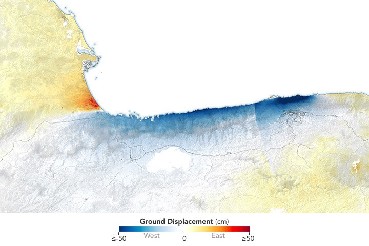
On June 24, 2026, a magnitude 7.2 earthquake struck northern Venezuela, followed by a magnitude 7.5 mainshock less than a minute later, causing severe damage and loss of life. The NISAR satellite, a joint project between NASA and ISRO, captured radar data showing how the ground shifted in regions like La Guaira and Caracas. Scientists used InSAR, a technique comparing pre- and post-quake satellite images, to measure horizontal and vertical displacement across the affected areas.
The displacement map highlights red areas where the ground moved east and up, and blue zones where it shifted west and down. Most displacement was horizontal due to the strike-slip fault mechanism, with some areas experiencing up to 60 centimeters of movement. A narrow white band near Morón marks the fault rupture zone, where little to no displacement occurred at the surface.
The fault responsible lies along the boundary between the Caribbean and South American tectonic plates, including the San Sebastián fault system. The rupture propagated offshore before moving back onshore near Caracas, contributing to extreme damage in coastal cities. Eric Fielding, a geophysicist at NASA’s Jet Propulsion Laboratory, noted that InSAR data provides critical insights into earthquake dynamics and damage patterns.
The displacement maps were delivered through NISAR’s Urgent Response system within 12 to 24 hours, supporting rapid disaster assessment. While preliminary, the data was later refined with precise orbit information to improve accuracy. This marks the first use of NISAR’s UR system for mapping surface displacement from a large earthquake, demonstrating its potential for future disaster response efforts.